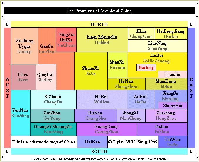
Chinese dialects

Schematic Representation of the Provinces of China

The diagram below shows the situation of China and the names of the provinces in Pinyin spellings (without tone markings and the usual English spellings where possible), and their Chinese character counterparts.

Next, after locating the general positions of the provinces, we aim to reduce the map of China to a simpler block diagram which will perserve the major boundary aspects and geographical positions relative to the compass. To do this, we first divide the country into four areas, the north west, north east, south east and south west areas respectively. Due to romanisations used in the past, some atlases may not contain Pinyin spellings, the alternative spellings are shown below in brackets.
 NORTH 
W
E
S
T
North West
  • Xinjiang Uygur (Sinkiang Uighur)
    Autonomous Region
  • Gansu (Kansu)
  • Qinghai (Tsinghai)
  • Ningxia HuiZu (Ninghsia Hui)
    Autonomous Region
  • Tibet
  • North East
  • Heilongjiang (Heilungkiang)
  • Jilin (Kirin)
  • Liaoning (Liaoning)
  • Inner Mongolia
    Autonomous Region
  • Hebei (Hopei)
  • Shanxi (Shansi)
  • Shaanxi (Shensi)
  • Henan (Honan)
  • Shandong (Shantung)
  • Beijing (Peking, [Beiping, Peiping])
  • Tianjin (Tientsin)
  • E
    A
    S
    T
    South West
  • Sichuan (Szechwan)
  • Yunnan (Yunnan)
  • Guizhou (Kweichow)
  • Guangxi-ZhuangZu
    ( Kwangsi-ChuangTzu)
    Autonomous Region
  • South East
  • Jiangsu (Kiangsu)
  • Anhui (Anhwei)
  • Hubei (Hupeh, Hupei)
  • Hunan (Hunan)
  • JiangXi (Kiangsi)
  • Zhejiang (Chekiang)
  • Fujian (Fukien)
  • Guangdong (Kwangtung)
  • Taiwan (Formosa, Taiwan)
  • Hainan (Amoy)
  • Shanghai (Shanghai)
  •  SOUTH 

    If we think of China as being a square, and then dividing it into the four areas described above, we can then subdivide the four smaller square into portions which mimic the provinces of China. The following is a representation which does not include Beijing, Tianjin, and Shanghai, but does show the islands of Taiwan and Hainan.

    The main problem with this simplified form is that certain provinces are not actually neighbours with those it seems to be next to (for example Hubei is has no border with Gansu). And those that do have borders with each other aren't shown as being so (for example Hebei and Inner Mongolia).

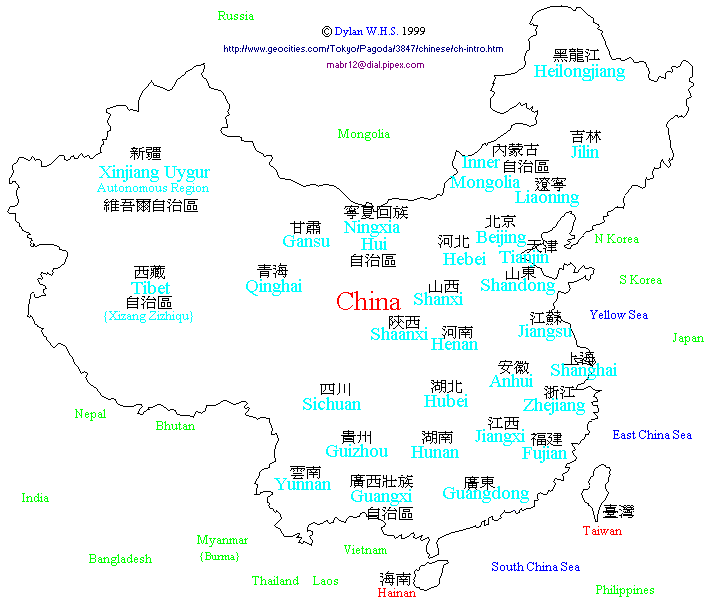
    By actual comparison with a map of the provinces, we must then move the borders around in this simplified map so that true neighbour to neighbour correspondence between provinces is achieved. The results are below, this time with the inclusion of Beijing, Tianjin and Shanghai. I have also included the names of the principle cities in each province.


    The schematic map of the provinces of China is essentially a 2D toplogical map. It is correct only so far as the following points.
  • Province to province borders remain true to a geographical map.
  • The relative sizes of each province is no indication of the true size of that province
    Chinese : Index : Homepage
    This page was created on Friday 30th July 1999 and last updated Thursday 25th April 2002.
    © Dylan W.H.S. 1996-onwards
    You can e-mail me here on anything you like!